Report
Life Among the Levees: A Historical Analysis of Community Adaptation in Lafourche Parish, Louisiana

Report
This paper would not have been possible without input from Windell Curole, former general manager of the South Lafourche Levee District, and Clifton Theriot, a native of Lafourche Parish who runs the Archives & Special Collections at Nicholls State University in Thibodaux. I would also like to thank Laci Melancon, executive director of the Coastal Center at Nicholls State University, who put me in touch with Windell and Clifton and has been incredibly helpful with all my research into southeastern Louisiana. Many thanks to the Roosevelt Institute for American Studies in Middelburg, Netherlands, particularly Gaetano Di Tommaso and Dario Fazzi, for giving me the opportunity to present this work. A big thanks to Dean Baker for his comments, Zorah Zafari for checking the numbers, and the communications team at the Center for Economic and Policy Research (Peter Hart, Lisa Burnam, and Adam Fishbein) for everything they do to get the organization’s work out to the public. Special thanks to my wife Kim and son Graham for their support, but not my beagle Daisy, who always gave them a hard time whenever I was away.
The story of Southern Louisiana’s relationship with the Mississippi River — both the good and the bad — goes back to pre-colonial times. The fertile floodplains around the Mississippi River helped indigenous people thrive for centuries, shaping their cultures and lifestyles. But elevation was also key to survival. The river posed a significant threat; its floods and shifting courses could destroy settlements and disrupt established community life (Mehta & Rodning, 2022). The Mississippi facilitated trade and transportation as European settlers displaced indigenous peoples and established permanent cities along the river. The land around the river changed, but the river itself did not. Flooding along its banks continued.
Before the creation of the US Army Corps of Engineers, solutions around flooding had less to do with taming the river and more with walling off settlements to protect them from its effects. Levees — manufactured or natural embankments built to reduce flooding risk — played a significant role in introducing agriculture in what was essentially a swamp, allowing towns to flourish in unlikely places. However, levees require continuous upkeep, and sometimes armed guards were necessary to protect them from sabotage. Farmers, for example, hoped that by causing a break in a levee downstream, they could relieve pressure on their own levees. In one particular case, officials took such action at Caernarvon, Louisiana, to protect the city of New Orleans, flooding farmland and displacing 10,000 people in St. Bernard and Plaquemines parishes (Horowitz, 2020).
That action occurred during the Great Mississippi Flood of 1927, once considered the worst disaster in US history and an event that would change the country’s flood control policy. Heavy rainfall over several months had strained the Mississippi River levees, and by mid-April, two breaks occurred near New Madrid, Missouri. These breaks were followed by a series of levee failures down to the Gulf of Mexico (Storey, 2005).
Engineers realized that levees alone could not prevent disasters like the 1927 flood. They pushed for other flood control measures — such as gates, spillways, pumps, and reservoirs — to redirect water during heavy rain (Bradshaw 2023). Congress agreed. The Flood Control Act of 1928 gave the Army Corps of Engineers authority over flood mitigation projects and the country’s levee system. Flood control was further prioritized by the Flood Control Act of 1936 (Federal Emergency Management Agency, 2020).
With Congressional support, the Army Corps set about installing flood control structures to tame the Mississippi. While the Army Corps was largely successful, the system had an unexpected and disastrous effect on the region. Without constraints, the Mississippi River will flow freely to the Gulf of Mexico, depositing sediments collected during its almost 3,000-mile journey and building land along the way. With flood controls in place, the river is stuck in one route to the Gulf, meaning less sediment ends on floodplains and wetlands. Instead, sediment that is vital to building land is dumped into the Gulf and off the continental shelf edge. This process has deprived wetlands, leading to their degradation. This effect can be seen on the western end of the Deltaic Plain, in places like Lafourche Parish. Without the Mississippi transporting sediments to these areas, communities are facing sinking land and encroaching Gulf waters.
While residents of the Mississippi River Delta have long had to deal with the threat of riverine flooding, the region’s sinking topography and location along the Gulf’s warm waters have also left communities at the mercy of ever-increasing hurricanes. These storms are not new to the region. The Gulf Coast has a long history of hurricanes, and several in particular have had a massive influence on flood control efforts and population migration in South Lafourche. The answer to this issue, at least in the 1960s, was surprisingly a return to levees as a method of flood control, despite the Flood Control Act of 1928’s abandonment of a levees-only approach. In South Lafourche Parish, this looks like an actual ring of earthen embankments circling communities. And what started as a community-funded project became the Army Corps-led Larose to Golden Meadow Hurricane Protection system. But have these efforts worked, and how have they affected South Lafourche?
This paper is a historical analysis of flood control in South Lafourche, focusing on evidence from a corpus of state and federal government documents and newspaper articles. This paper aims to understand how the work around the Larose to Golden Meadow Hurricane Protection System has affected South Lafourche’s communities, settlement patterns, and the region’s economy. Historical context is key. The adaptations of communities to past changes offer valuable insights into potential future challenges. Given the current discussions surrounding climate change, this research is crucial in empowering communities to make informed decisions and take action towards protecting their culture and livelihoods.
The paper’s first section examines the history of South Lafourche, which is marked by its unique geography, a mix of cultures, and a struggle against disasters. Indigenous tribes were the first to settle in the Bayou Lafourche region, followed by waves of French, Spanish, and American settlers. The bayou’s prominence and the economic activities it supports have fostered unique settlement patterns over time. However, the bayou’s connection to the Mississippi River and the Gulf of Mexico and the land subsidence caused by changes to the path of the Mississippi River have left South Lafourche’s communities vulnerable to riverine flooding and hurricanes.
The second section looks at the Larose to Golden Meadow Hurricane Protection system, a project that emerged in the aftermath of Hurricane Betsy in 1965. The project aimed to provide South Lafourche with storm surge protection. However, due to funding issues, land disputes, and environmental concerns, the project faced decades of delays and modifications and was only 95 percent complete by 2005, when Hurricane Katrina struck. Following Katrina, the Army Corps of Engineers and the South Lafourche Levee District butted heads regarding costs, timelines, and new levee standards. As a result, South Lafourche decided to seek funds and carry out construction work independently.
The third section uses various socio-economic indicators to provide a snapshot of South Lafourche today and the effects the Larose to Golden Meadow system has had on the region. Indicators include population changes, social vulnerability, economic losses, flood insurance, and employment.
Finally, the fourth section will discuss policy implications based on the paper’s findings. The section highlights the ongoing challenges of land subsidence, sea-level rise, and intensifying hurricanes due to climate change, necessitating continued work on the Larose to Golden Meadow Hurricane Protection System. The section proposes greater federal involvement in the areas of flood mitigation and funding while also acknowledging and respecting local needs. But, it also looks at local initiatives, such as workforce development, that can help communities and their economies adapt.
While existing historical research extensively covers the challenges of living along the Gulf Coast or the Mississippi River and its tributaries and distributaries, this paper concentrates on a smaller region within southeastern Louisiana, emphasizing the importance of examining these challenges at a micro level. While South Lafourche’s struggle with riverine flooding and hurricanes may not be unique compared with all other communities on the Gulf Coast, its history is — and that can provide insights into future adaptation and resilience.
Understanding the geography of Lafourche Parish is vital to understanding its history. The parish is centered around the eponymous Bayou Lafourche, which branches off from the Mississippi River near Donaldsonville in Ascension Parish and then runs 120 miles down the Gulf. The elevation of the land ranges from less than two feet south of Golden Meadow to 12 feet at Thibodaux in the north, with most of the land only a few feet above sea level (Ditto, 1980).
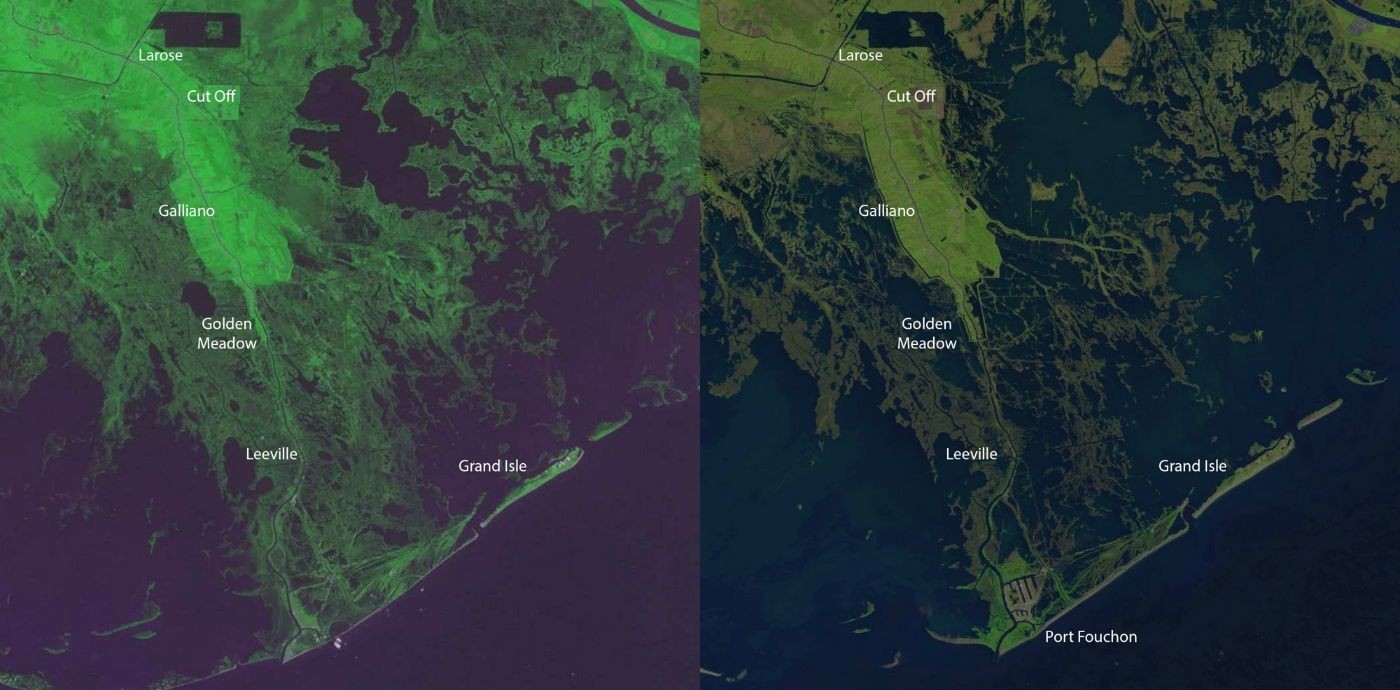
South Lafourche’s shape is not unlike Florida, a peninsula pushing out into the ever-encroaching Gulf waters. The Florida metaphor only works for South Lafourche in its present state, though; in the not-so-distant past, wetlands acted as connective tissue holding the land together (Figure 1).
Figure 1: USGS Satellite Comparison of Southern Lafourche Parish, 1972 and 2024
Bayou Lafourche runs down the left of the peninsula’s center, with Highway 1 parallel on the west bank and LA 308 on the east bank. Where the peninsula ends, the bayou and Highway 1 continue down to Port Fourchon and Grand Isle, which sits in the Gulf like a Cuba to South Lafourche’s Florida. Despite being connected to South Lafourche like a limb extended into the Gulf, Grand Isle is actually part of neighboring Jefferson Parish. However, its history and fate are linked to Bayou Lafourche, since Highway 1 is the main hurricane evacuation route north.
As Figure 1 illustrates, the land was not always as it appears today. Lafourche Parish was once the ancestral home of the Chitimacha Tribe of Louisiana. The tribe’s lands encompassed the Atchafalaya Basin and the areas westward toward Lafayette, southward to the Gulf of Mexico, and eastward to New Orleans (d’Oney, 2020).
As European powers competed for dominance over the North American continent, settlement of the region steadily increased. Louisiana changed hands between the French and the Spanish, who ruled the area from 1763 to 1803, before switching to France again for a shorter period (Police Jury Association of Louisiana, 2018; Thibodaux Chamber of Commerce, 2001).
Because of the patterns of settlement in Lafourche and adjoining parishes over the centuries, the area had become home to a unique “Cajun culture” — the result of the diverse mix of French, Spanish, English, and German settlers, Acadians deported from Nova Scotia by the British, indigenous peoples, and enslaved peoples forced to work the sugar cane plantations (Becnel, 1962).
Economic activities along the bayou created a unique pattern of housing development running throughout the entire parish. The houses that line the bayou were so close together that residents claim a message could travel from porch to porch from the farthest point north to the very south. For this reason, Bayou Lafourche has been referred to as “the longest … street in the world” (Nierlich, 1963). Industries such as shrimping, fishing, farming, and later oil and gas extraction helped shape the towns along the bayou and their future growth.
Living so close to the bayou and the Gulf had its share of hazards, the two most significant being flooding and hurricanes. Though many hurricanes have impacted the region, five hurricanes in particular have contributed to population shifts and changes in flood control throughout South Lafourche. The first was the Great Cheniere Hurricane of 1893, which made landfall at Cheniere Caminada, a small fishing community situated on a peninsula west of Grand Isle. On the night the hurricane made landfall, it is believed that 779 of the island’s approximately 1,500 residents died, many of them children. The deaths were caused either by the 16-foot storm surge or by collapsing roofs as people sought refuge in their homes. Many survivors moved to what are now Golden Meadow, Larose, Leeville, Cut Off, and Galliano (Ditto, 1980; Hall, 2016).
Moving further inland offered residents protection from storm surges, but the risk of flooding persisted. Being a distributary of the Mississippi, Bayou Lafourche was also prone to the same extreme flooding events as its parent channel. Parish law required landowners to construct and maintain levees along their bayou-front property. However, flooding over time became worse, and it was unclear whether the cause was an increasing flow from the Mississippi or increasing development in the region leading to higher losses. Local interests toward the northern end of the bayou fought before the legislature to dam the entrance at the Mississippi, believing seasonal flooding to be the cause (Kane, 1943, p. 188). As the risk of flooding subsided, levees among the bayou were utilized for agriculture or dismantled entirely.
The dam at Donaldsonville may have mitigated riverine flooding, but at the opposite end of the bayou, it was harming Leeville, the southernmost community in Lafourche. A small fishing community 12 miles north of Bayou Lafourche’s mouth, Leeville once boasted orange groves, rice fields, a school, a church, and a grocery store. However, the bayou’s slowing current allowed saltwater from the Gulf to intrude, ultimately rendering the land unsuitable for farming. The intrusion of Gulf water into Leeville also resulted in severe coastal marsh deterioration and erosion, increased flooding during storms and high tides, and possibly the fastest rate of land loss globally (Ditto, 1980; Doucet, 2019).
Around this time, the second and the third of the five hurricanes hit. In September 1909, a Category 3 hurricane passed over Morgan City, west of Lafourche Parish, before moving northeast between Baton Rouge and New Orleans (Roth, 2010).
The 1909 hurricane was significant because it was the first blow in a one-two punch. Six years later, in September 1915, another hurricane struck Grand Isle. Again, this hurricane was described by Cline as “the most intense hurricane of which we have record in the history of the Mexican Gulf coast, and probably in the United States” (Cline, 1915).
The 1915 hurricane was the breaking point for those in Leeville who stayed after the 1909 hurricane. Residents migrated farther inland to Golden Meadow and Cut Off, which still provided access to the bayou but were safer from storm surges at the time (Ditto, 1980). No population data is available on Golden Meadow before its incorporation in the 1950s, but anecdotal evidence suggests a surge in economic activity and development in the early 1900s. The town became an important gateway and outpost for vacationers heading down to Grand Isle and fishers and shrimpers trawling the bayou and marshlands beyond.
Golden Meadow’s economy mainly relied on fishing and trapping (Horowitz, 2020).
In 1928, the oil and gas industry brought Leeville back to life. A seismograph of the region discovered a salt dome at Leeville. By 1931, the Texas Company — also known as Texaco — had completed its first producing well at the Leeville field, producing over 157,000 barrels that year. By 1934, the Leeville field had 52 wells, producing over four million barrels annually (Doucet, 2019).
Building oil and gas infrastructure in marshland proved to be an enormously complex task. Except for the New Orleans, Fort Jackson, and Grande Isle Railroad — which, despite its moniker, at one point only traveled as far south as Buras in Plaquemines Parish (New Orleans and Lower Coast Railroad Company, 1977) — railroad lines did not extend as far south as Larose in South Lafourche. Hauling equipment had to be done via the parish’s unpaved roads and waterways.
Ensuring the navigability of the Mississippi River and its distributaries for trade had long been a key concern for Congress. Some of that work involved carving new paths through marshland. In 1873, Congress approved the creation of the Gulf Intracoastal Waterway to offer a secure and effective transportation route from Texas to Florida for commercial and military vessels. Some sections of the waterway would consist of existing channels, but others required constructing new canals to essentially create a highway for boats. This network of channels and canals would allow ships to bypass the difficulties of navigating the open waters of the Gulf.
The project, however, faced delays. The railroads, which would face significant competition from the waterway, drove water carriers out of business through rate-cutting and declining to transfer goods that could be transported using both methods (Alperin, 1983; Leatherwood, 1976). The discovery of oil and the need to expedite oil shipments during World War II tipped the scales in favor of the Intracoastal Waterway. The construction would have a profound effect on South Lafourche.
In Larose, settlers had maintained a canal connecting farmers to markets in New Orleans. In 1925, the federal government took control of the canal and used the bayou to travel north to Lockport to transport goods. By 1943, to shorten transportation times, the government abandoned the Larose-to-Lockport route and dredged across Bayou Lafourche, creating the Intracoastal Canal (Ditto, 1980; The Historical Marker Database, 2023). This move cut Larose into a distinct “cloverleaf” shape. The waterway’s main cargo shifted from farm produce to oil, sulfur, shells, and equipment.
The Intracoastal Canal led to new shipyards and related businesses in Larose and South Lafourche, which brought workers to the area. However, the increasing number of man-made canals created for navigability and laying down oil and gas infrastructure introduced new problems. With the post-1927 river control structures locking the Mississippi into place and the bayou’s water supply cut off at Donaldsonville, South Lafourche was being deprived of sediments and, as a result, sinking. And the man-made canals are like open wounds, allowing salt water into wetland ecosystems that rely on freshwater from sources like the bayou. Combining factors like subsidence and sea-level rise, Louisiana has experienced a loss of 1,900 square miles of coastal land, mostly marshes, since the 1930s (Kennedy, 2013).
Also, oil and gas extraction was not slowing down — it was expanding from the coast to the Outer Continental Shelf. The first offshore oil well opened in the late 1930s near Cameron Parish in southwestern Louisiana, and by the late 1940s, several other companies had established wells in the Gulf (Greater Lafourche Port Commission, 2017a; Sprehe, 2004). However, Port Fourchon and Grand Isle’s connection to South Lafourche is Highway 1 and the Leeville Bridge, an area seeing increasing inundation and saltwater intrusion. While Highway 1 would eventually be elevated, there were the issues of establishing a secure evacuation route for Port Fourchon’s thousands of employees and Grand Isle’s residents while also protecting South Lafourche residents from storm surge.
Concerns over these issues led community leaders, business people, and residents to join forces to advocate for increased storm protection in the area. In the early 1960s, the Lafourche Parish Police Jury funded the construction of a 36-mile low-rise levee system that extended from Larose to the Golden Meadow area. The system was approximately 1.5 miles from Bayou Lafourche, five feet tall, and drained by several low-lift pumps (Ditto, 1980; Staff Writer, 2018; US Army Corps of Engineers, New Orleans District, 1984). In hindsight, the Police Jury levee was both insufficient and better than nothing. Had the Police Jury levee not existed, South Lafourche may not have survived the fourth hurricane to impact the region significantly.
In September of 1965, that fourth hurricane struck. Prior to Katrina in 2005, Hurricane Betsy was “both in terms of numbers of people affected and in terms of monetary losses” the worst hurricane to hit Louisiana (Hearings Before The Special Subcommittee to Investigate Areas of Destruction of Hurricane Betsy, 1965).
In the aftermath of Betsy, Lafourche Parish and other coastal parishes requested federal help to elevate the levees to a height that would protect communities from hurricanes. In response, Congress passed the Flood Control Act of October 1965. The act funded projects by the US Army Corps of Engineers that would provide coastal parishes with the same protection from storm surges as they had from riverine flooding (Cowdrey, 1977). For South Lafourche, this meant a ring levee that lifted the existing Police Jury levees and expanded the protection area. The project was called the Larose to Golden Meadow Hurricane Protection System.
Although the project was launched in 1965, it would take a decade to get off the drawing board. In 1967, Congress appropriated $200,000 to start preconstruction engineering and design. Construction funds were appropriated five years later, in 1972 (Rowan, n.d.; US Army Corps of Engineers, New Orleans District, 2014). Construction finally started in 1976 (Louisiana Coastal Protection and Restoration Authority, 2013).
So why did it take so long? Before the 1973 final environmental statement, there is not much documentation available to say for sure. A constant criticism of the Army Corps is that it has historically taken years, even decades, to complete project feasibility studies, which are typically supposed to take three years (US Government Accountability Office, 2024). In this case, the likely factors that delayed the project include the fact that the project’s enormous scope and complexity required extensive planning and coordination. As is often the case with large-scale projects, challenges were likely encountered in securing consistent funding and coordinating between federal and state stakeholders. The non-federal sponsor, in this case, was the Lafourche Parish Police Jury, which acted as the parish’s governing body, much like a county board of supervisors or county council. According to a report by the US Army Chief of Engineers on Civil Works activities, the federal government sought various assurances from the Police Jury before work could start, including:
Provide lands, easements, rights-of-way, and spoil-disposal areas for construction and future maintenance; alter pipelines, cables, wharves, oil wells, and any other facilities for construction, all at an estimated cost of $3,180,000 including $1,150,000 cash contribution or equivalent work specifically undertaken as part of project; prevent encroachment on ponding areas unless substitute storage capacity or equivalent pumping capacity provided promptly without cost to the United States; maintain and operate all works after completion; and hold the United States free from damages (US Army Corps of Engineers, 1967, p. 576).
The police jury approved the assurances in February of 1967, but in 1968 the responsibility of the non-federal sponsor shifted from the Lafourche Parish Police Jury to the newly formed South Louisiana Tidal Water Control Levee District, later renamed the South Lafourche Levee District in 1970 (South Lafourche Levee District, 2024). By 1973, the levee district had an agreement with the federal government that the local government would pay for 30 percent of the then-estimated $3 million (US Army Engineer District, New Orleans, 1973) — though the project would eventually exceed that. The levee district’s share came from local taxes and state grants (Louisiana Coastal Protection and Restoration Authority, 2013).
With public funds being used, transparency was necessary. Officials held numerous meetings between local government groups and citizens in the district and the project area. Local groups expressed a desire to cooperate, with the Lockport Rotary Club, Golden Meadow Lions Club, and the South Lafourche Jaycees endorsing the project (US Army Engineer District, New Orleans, 1973). However, issues around right-of-way and easements ended up in court. Windell Curole, who was named General Manager of the South Lafourche Levee District in 1980, said, “People don’t want you to take their property.”1
In one 1982 case, Terrebonne v. South Louisiana Tidal Water Control Levee District, the Terrebonne family sued the levee district because it appropriated two tracts of land owned by the family to build a levee as part of the Larose to Golden Meadow project. The district cited Louisiana Civil Code Article 665, which lets the government take land “for the public or common utility … and for the making and repairing of levees, roads, and other public or common works” (Louisiana State Legislature, n.d.). The Terrebonne family claimed that Article 665 should not apply to their land because it was too far from the bayou. The family also felt that the levee district was unfair by only offering them the assessed value for their land while other landowners were paid full market value (Terrebonne v. South Louisiana Tidal Water Control Levee Dist., 1982). The court decided in favor of the levee district.
In another 1982 case that adopted a different approach, Allain-Lebreton Company v. Department of the Army, New Orleans District, Corps of Engineers, et al., the Allain-Lebreton Company sued the Army Corps because engineers decided not to locate a hurricane protection levee on the company’s land. The company had offered land without compensation on the condition that the levee be built in an area enclosing wetlands, which the company wanted to drain and develop. The Army Corps rejected the offer because they wanted to leave the wetlands in their natural state. The district court dismissed the case (Allain-Lebreton Co. V. Department of Army, New Orleans Dist., Corps of Engineers, 1982).
The decision to minimize effects on the wetlands likely came from a shift in attitudes toward the environment during the 1970s. With the creation of the Environmental Protection Agency in 1970 and an increasing number of laws around water quality and wetland protection, environmental concerns likely necessitated thorough assessments and mitigation efforts. One example is the National Environmental Policy Act (NEPA), signed into law on January 1, 1970, which required federal agencies to prepare Environmental Impact Statements for any projects that could impact the environment (Environmental Protection Agency, 2013). Another was the overhaul of the Clean Water Act in 1972, which set goals to achieve an interim water quality level that protects fish, shellfish, wildlife, and recreation by 1983 and eliminate all pollutants discharged into navigable US waters, including wetlands, by 1985 (Environmental Protection Agency, 2016). As discussed later, these laws played a role in overhauling sections of the project even after construction began.
The initial project consisted of increasing the height of the existing 43 miles of levees surrounding the area. The project also called for constructing an additional four miles of levees and new features to enhance drainage and help with boat navigation (US Army Engineer District, New Orleans, 1973). Under the proposal, 2,710 acres of marshland south of Yankee Canal, which lies east of Golden Meadow, would be leveed and drained.
According to the final environmental statement, the US Army Engineer District considered four alternatives. The first would have been to update building codes to require the base height elevation of future housing projects to be above the anticipated height of the tidal surge. The second alternative would have required building codes to be updated to include standards for structural stability strong enough to withstand projected wave and water forces caused by hurricane tides. The third alternative would have been constructing a new set of levees north of Yankee Canal instead of utilizing already-constructed low-level tidal levees. The final alternative would have been to do nothing (US Army Engineer District, New Orleans, 1973).
The problem with most of these alternatives is that they didn’t consider what would happen to current residents and existing structures, only future development. The third option was rejected due to cost considerations; expanding the existing levees was more economical than constructing new ones along a different route.
However, the no-action alternative would have spared the 2,710 acres of marsh south of Yankee Canal. This part of the project received the most pushback from state, federal, and non-governmental organizations. The marsh’s brackish water is a crucial nursery for various species, including brown shrimp, white shrimp, blue crabs, oysters, and menhaden. The report emphasizes that these species, particularly shrimp, are vital to the livelihoods of many Bayou Lafourche residents (US Army Engineer District, New Orleans, 1973, p. VIII–17).
As mentioned previously, the system has undergone several modifications almost 60 years since authorization. Two changes to the project occurred before construction began. Initially, the levees were supposed to end at Golden Meadow. The Lafourche Parish Police Jury passed a resolution on June 10, 1967, to extend the levees two miles south of Golden Meadow. This change added 1,800 acres to the project, including the area’s largest manufacturing facility, a seafood processing plant. (Rowan, n.d.). Another change occurred around the design of a drainage system. The Army Corps of Engineers approved gravity drainage structures, but locals insisted on and paid for the construction of pumping stations.
In 1984, another modification was made, revising the levee alignments at Clovelly Farms and Louisiana Land and Exploration Company, east of Bayou Lafourche. The new levee alignment at Clovelly Farms added 2,468 acres to the protected area, with about 1,300 acres used to grow sugarcane. The new levee alignment for the Louisiana Land and Exploration Company added 3,296 acres of previously cleared land, with 2,500 of those acres mainly used for pasture (Rowan, n.d.).
By 1985, the project had been modified yet again. The South Lafourche Levee District requested that the levees be realigned to include agricultural lands within the system. The Army Corps also discovered that 2,079 more acres of wetlands would be impacted than previously analyzed (US Army Corps of Engineers, New Orleans District, 1987a).
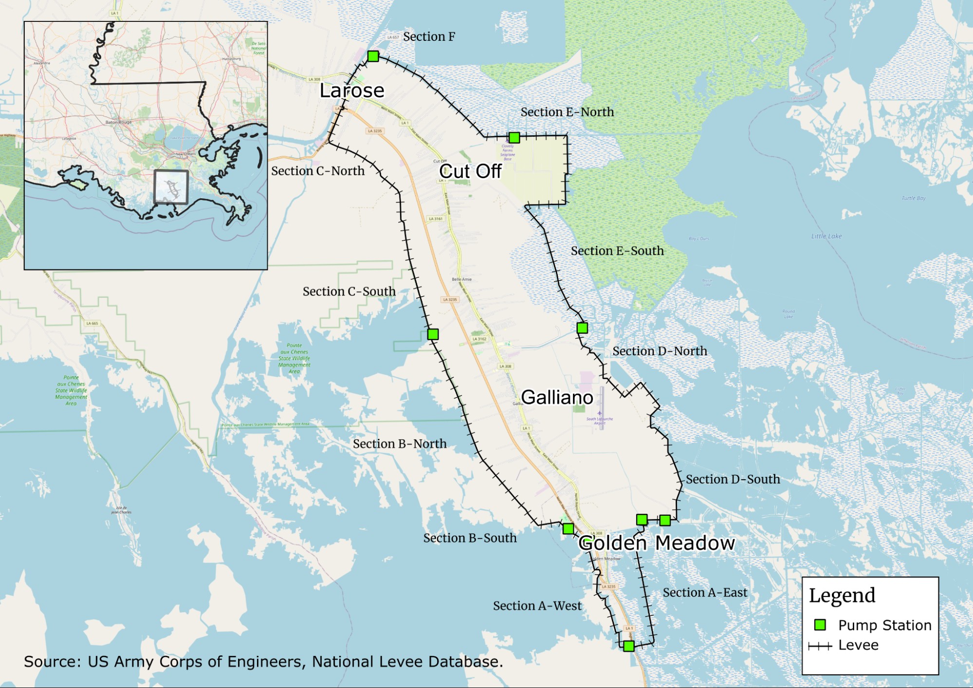
Figure 2: Larose to Golden Meadow Hurricane Protection System and Pumping Stations
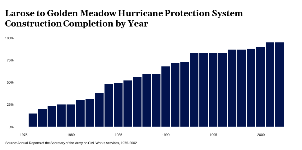
The first lifts on levees near Golden Meadow were completed within a couple of years of construction starting. However, due to the soil foundation conditions, the levees needed to be built in three separate stages, or lifts, to reach the authorized elevation (US Army Corps of Engineers, New Orleans District, 2011). By 1984, construction was still ongoing on the first lifts.
The system was only 50 percent complete when it had its first test in 1985 as Hurricane Juan struck the region. The project’s partially completed sections experienced no failures. However, locally constructed levees at Bully Camp and Yankee Canal failed due to gaps left for pump station construction access. The estimated damages were $35 million (US Army Corps of Engineers, New Orleans District, 1987b).
Even after Hurricane Juan hammered home the need for protection, progress on the project remained slow. By 1987, the Army Corps had stopped including updates on specific project segments in its annual reports. After 2003, despite the project remaining incomplete, the percentage of work left also was no longer reported in the Army Corps’ annual reports. By 2005, almost 30 years after construction began and 40 years after Hurricane Betsy, the project was still only 95 percent complete (Rowan, n.d.; South Lafourche Levee District, 2024).
Figure 3
But in 2005, the fifth hurricane in South Lafourche history to have a major impact would hit, and bring with it yet another shift in the nation’s view on flood control. On August 29, 2005, Hurricane Katrina made landfall in Louisiana as a Category 3 hurricane. A record-breaking storm surge pushing through Lake Borgne east of the city of New Orleans, combined with breaks in the levees along Lake Pontchartrain, resulted in widespread flooding throughout the city’s Lower Ninth Ward and adjoining St. Bernard Parish. Yet again, southern Louisiana had experienced the worst hurricane in the state’s history. This time, however, climate change and the possibility of increasing extreme weather events entered the conversation over what to do next, and locals and the federal government found themselves at odds on how to proceed.
Hurricane Katrina marked a clear turning point in the Army Corps’ involvement with the Larose to Golden Meadow Hurricane Protection System. During Katrina, the system successfully prevented flooding within the project area, although one reach of the levee berm and the Point-Au-Chien mitigation levee sustained damage (Woodley Jr., 2006). Hurricane Katrina and later Hurricane Rita brought about a change in the Army Corps of Engineers’ levee management procedures. In 2007, Congress passed the Water Resource Development Act (WRDA), which called for recommendations for a National Levee Safety Program.
The act required a reevaluation of the Larose to Golden Meadow system that detailed modifications necessary to “achieve the certification required for a 100-year level of flood protection in accordance with the national flood insurance program” (Woodley Jr., 2008).
However, the Army Corps and the South Lafourche Levee District disagreed over issues of cost and time. A post-Katrina evaluation of New Orleans’ levee system, which had been built by the Army Corps, showed that it had engineering flaws. One aspect was the materials used in construction. The report noted:
Some sections of levees were constructed with higher-quality (from an erosion perspective) materials than others, basically clays hauled in versus lower-quality soils dredged (the method termed hydraulic fill) from adjacent areas (as along the [Mississippi River-Gulf Outlet Canal]) (Interagency Performance Evaluation Task Force, 2009, p. I–30).
According to the evaluation, the type of fill, particularly the quality of clay, played a huge role in whether a levee was susceptible to erosion from overtopping. The report stated that when designing structures, engineers need to think about a wider range of potential outcomes, including how well levees and floodwalls can handle being overtopped (N. Carter & Normand, 2024). South Lafourche’s own experience with the Larose to Golden Meadow project likely influenced its next move.
There was also a question of federal support. Under the Department of Defense, Emergency Supplemental Appropriations to Address Hurricanes in the Gulf of Mexico, and Pandemic Influenza Act, 2006, signed by President Bush, Larose to Golden Meadow and other projects received money for post-Katrina repairs (Louisiana Coastal Protection and Restoration Authority, 2007; US Army Corps of Engineers, New Orleans District, 2007) . With more hurricane seasons on the way, South Lafourche did not have more time.
In 2006, under Curole’s leadership, the South Lafourche Levee District decided to go ahead on its own, asking voters to approve a one-cent sales tax to fund improvement work, including bringing the levees up to design specifications. Officials stated the sales tax would raise $4.5 million each year, supplementing the $2.5 million it already receives annually from property taxes (South Lafourche Levee District, 2024).
With the voters’ approval, the Levee District began securing additional funding to improve the system. Louisiana’s Coastal Protection and Restoration Authority provided funding, supplemented by money from the Gulf of Mexico Energy Security Act (GOMESA), which distributes a portion of federal revenue generated from offshore oil and gas exploration in the Gulf of Mexico to four coastal states: Louisiana, Mississippi, Alabama, and Texas. Louisiana’s Bond Commission also approved $7 million in bonds for the use of levee construction, maintenance and flood protection in South Lafourche (Gaudet, 2006).
As early as 2006, the Army Corps cautioned South Lafourche that it would halt any improvements if the work did not comply with the post-Katrina levee requirements. However, the landfall of Hurricanes Gustav and Ike on September 1 and 12, 2008, respectively, underscored the need for swift action. Several sections of the Larose to Golden Meadow project sustained damage. The Army Corps initiated a project implementation report to repair the damage (Louisiana Coastal Protection and Restoration Authority, 2010).
By 2010, the Army Corps decertified the levee system, claiming the unauthorized work had “an unacceptable operation and maintenance compliance rating” and the system was “below [the] 1965 authorized level of risk reduction” (Melendez, 2024). When it came to the Larose to Golden Meadow system, South Lafourche and Louisiana were now on their own.
The question now is whether the Larose to Golden Meadow Hurricane Protection System has improved the lives of South Lafourche residents.
This section uses various indicators to provide a current snapshot of South Lafourche communities. Where data are available, the report compares before and after the Larose to Golden Meadow Hurricane Protection system, but many datasets do not go back that far. The following indicators were analyzed to examine the current state of South Lafourche: population, social vulnerability, economic losses, flood insurance, and employment.
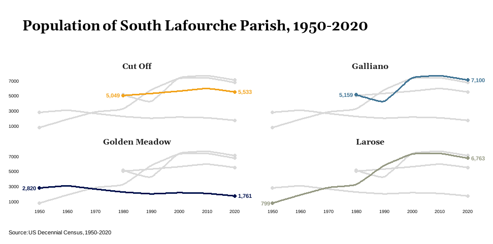
The towns of South Lafourche — except Golden Meadow, which has far less available land for development — have experienced population growth since the hurricane protection system was built. However, in the last few decades, population numbers have stagnated (Figure 4). This may be attributable to several factors, one of which is social vulnerability.
Figure 4
According to the Centers for Disease Control and Prevention (CDC), certain social conditions within a community can influence its capability to reduce death and injuries and financial losses during a disaster. These social conditions may include factors such as high poverty rates, low vehicle accessibility, and overcrowded housing (Centers for Disease Control and Prevention/ Agency for Toxic Substances and Disease Registry/ Geospatial Research, Analysis, and Services Program, 2022). The CDC created an index that determines a region’s social vulnerability by examining data based on four themes: socioeconomic status, household composition and disability, minority status and language, and housing type and transportation. Looking at South Lafourche by Census tracts using 2022 data (Figure 5), the tract containing Galliano scored in the 81st percentile in Louisiana in vulnerability, followed by the tracts containing Golden Meadow (55th) and Cut Off (68th).
Figure 5: Overall Social Vulnerability Index for South Lafourche by Census Tracts, 2022
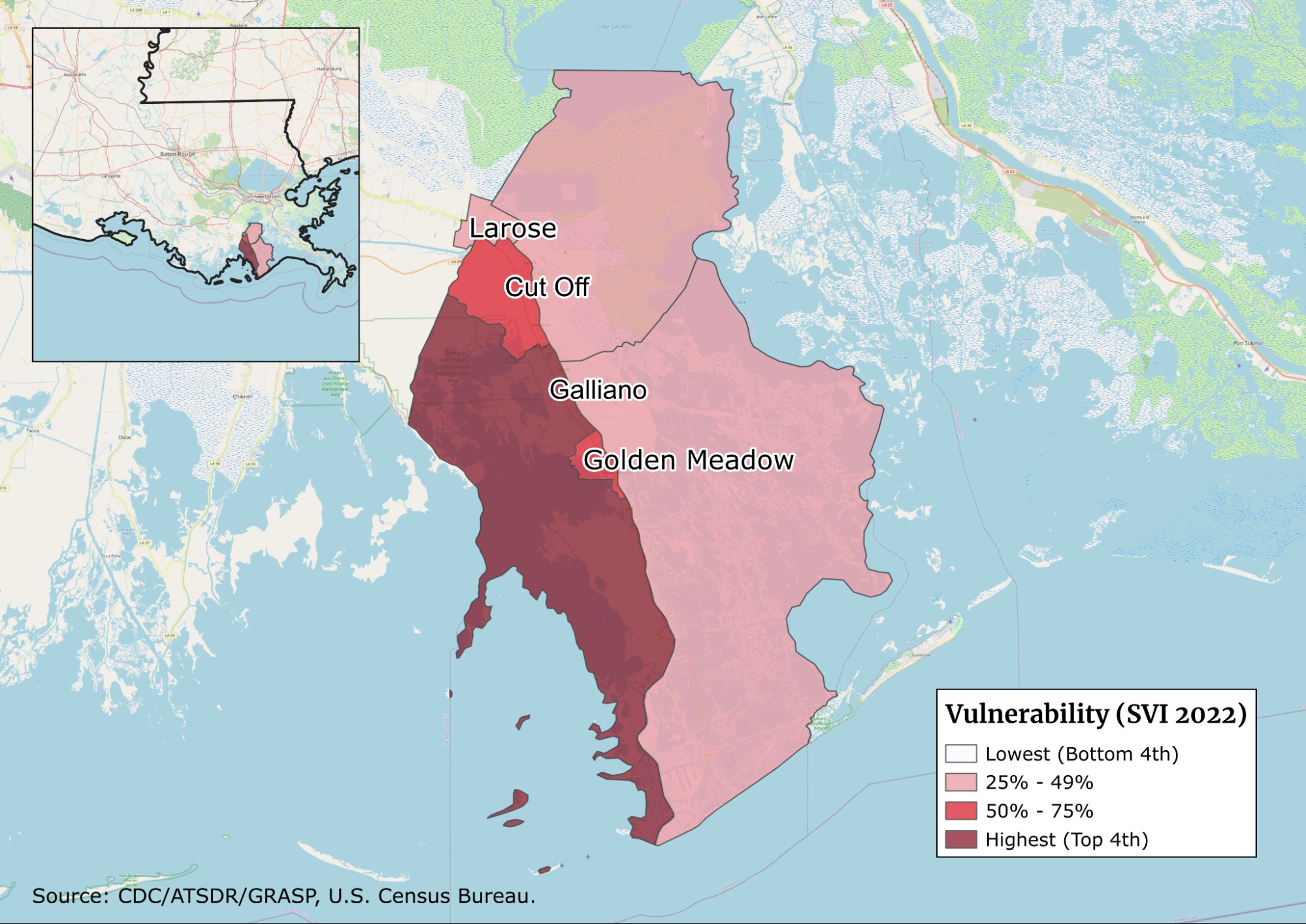
Looking at the themes individually, the Census tract containing Galliano was in the 84th percentile for the percentage of mobile homes and the 87th percentile for the percentage of households with more people than rooms. The census tract containing Cut Off was in the 74th percentile for the percentage of mobile homes. Mobile homes fill an essential gap in the US housing market by providing affordable housing options for families who are unable to find suitable housing through the market or state-subsidized programs. However, research has found that families living in mobile homes have higher flood exposure and that post-disaster regulations and recovery policies tend to treat mobile homes differently than other housing, limiting the amount of aid families may receive (Rumbach et al., 2020; Tate et al., 2021).
Of course, housing is tied to another factor affecting people’s lives in South Lafourche: flood insurance.
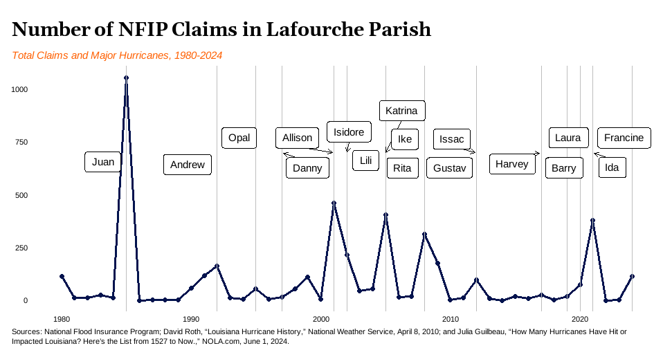
Figure 6 below shows two significant trends in flood insurance. The first is that the number of claims in 1985 following Hurricane Juan illustrates the damage to Lafourche communities before the Larose to Golden Meadow hurricane protection system was implemented. The second is that the number of claims for each succeeding hurricane has decreased over time. However, there are some important caveats. The first is that the data represents all of Lafourche Parish, as community-level data is unavailable. The second is that since 1980, the number of significant hurricane events in the region has increased.
Figure 6
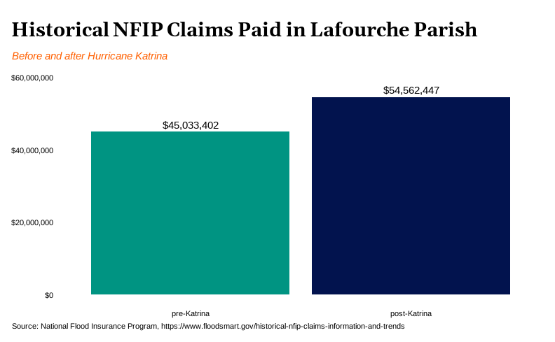
While individual claims per hurricane have been reduced, more recent hurricanes have been costlier (Figure 7). NFIP claims paid in the post-Katrina period total around $55 million. Nearly half of that amount, almost $27 million, is attributed to Hurricane Ida claims in 2021 alone, not taking into account inflation.
Figure 7
As noted earlier, the NFIP data is for the entirety of Lafourche Parish. It is possible that the costs to the NFIP would be much higher in the post-Katrina period without the Larose to Golden Meadow Hurricane Protection System. There is some evidence to support this claim. A legal complaint filed by multiple states, parishes, municipalities, levee districts, drainage districts, and associations against the Department of Homeland Security, FEMA, and related officials over NFIP rate changes noted that despite Hurricane Ida’s storm surge being twice as high as Hurricane Juan’s in 1985, not a single house within the ring levee flooded (The State of Louisiana et al. V Alejandro Mayorkas, the Department of Homeland Security, Deanne Criswell, the Federal Emergency Management Agency, and the Federal Insurance and Mitigation Administration, 2023). According to Curole, “Ida hit and everything worked to a tee.”2
Another potential explanation for the reduced number of claims per hurricane could be that the number of individuals opting to go uninsured may have risen. Two factors support this: the decertification of the levee system and the aforementioned changes to NFIP policies under Risk Rating 2.0. When a levee loses accreditation, the area is mapped as a high-risk flood zone on a flood insurance rate map (Federal Emergency Management Agency, 2021). In 2021, FEMA sought public comment on new flood maps for Lafourche Parish. These maps did not incorporate the Larose to Golden Meadow levee system, as FEMA relies on maps provided by the Army Corps of Engineers (Campo, 2023).
The other factor is that in 2021, FEMA announced that the NFIP would switch to a new pricing methodology called Risk Rating 2.0, which is designed to be more precise and equitable in setting rates. Under the previous method, FEMA used outdated flood maps to determine risk. Risk Rating 2.0 considers several elements — including the property’s distance to a water source, its elevation, and the cost of rebuilding — which lead to more accurate premiums. But that actuarial accuracy in calculating risks has increased premiums in a market where homeowners are already struggling with the costs of homeowners insurance and add-on policies for hazards such as wind. Between 2018 and 2022, the average risk-based cost of flood insurance in Louisiana increased by 113 percent (Sedlar, 2023).
As mentioned earlier, Louisiana and its parishes, towns, and levee districts joined other states in filing a legal complaint, stating Risk Rating 2.0 ignores “historical observed flood events and demonstrably effective mitigation efforts in favor of future flood hypotheticals to determine the flood risk of each insured property” (The State of Louisiana et al. V Alejandro Mayorkas, the Department of Homeland Security, Deanne Criswell, the Federal Emergency Management Agency, and the Federal Insurance and Mitigation Administration, 2023, p. 7). However, the Eastern District of Louisiana court partially dismissed the case in 2024 due to lack of standing for many of the plaintiffs and their claims (State of Louisiana, et al. V Department of Homeland Security et al., 2024).
The final piece is the number of uninsured. According to FEMA data on residential penetration rates, around 74 percent of residential structures in the entire parish are uninsured (Federal Emergency Management Agency, 2025). This amount is calculated using the ratio of insured residential structures to total residential structures, taken from the 2019 National Structure Inventory (NSI) 2.0. Private flood insurance is not included, but that hardly affects these estimates. According to Rep. Steve Scalise, who represents Louisiana’s 1st Congressional District, which includes Lafourche Parish, “For many in southeast Louisiana and across the country, the National Flood Insurance Program is the only game in town” (Ballard, 2024). The high rate of uninsured also could explain the decrease in total number of claims. However, because the available data encompasses the entire Lafourche Parish and not specifically South Lafourche, the extent to which the uninsured population influences claim numbers within the study area remains uncertain.
Flood insurance rates and coverage are not isolated issues. The financial burden they place on residents is closely intertwined with their ability to earn a living, which ties into the next indicator: employment.
As noted previously, South Lafourche’s proximity to Port Fourchon provides employment opportunities for residents. According to the Greater Lafourche Port Commission, the port serves and/or is home to five of the top ten employers in Lafourche Parish (Greater Lafourche Port Commission, 2017b). The industry has become so dominant that oil and gas extraction employment has outpaced more traditional agriculture and fishing jobs in the parish (Figure 8).
Figure 8
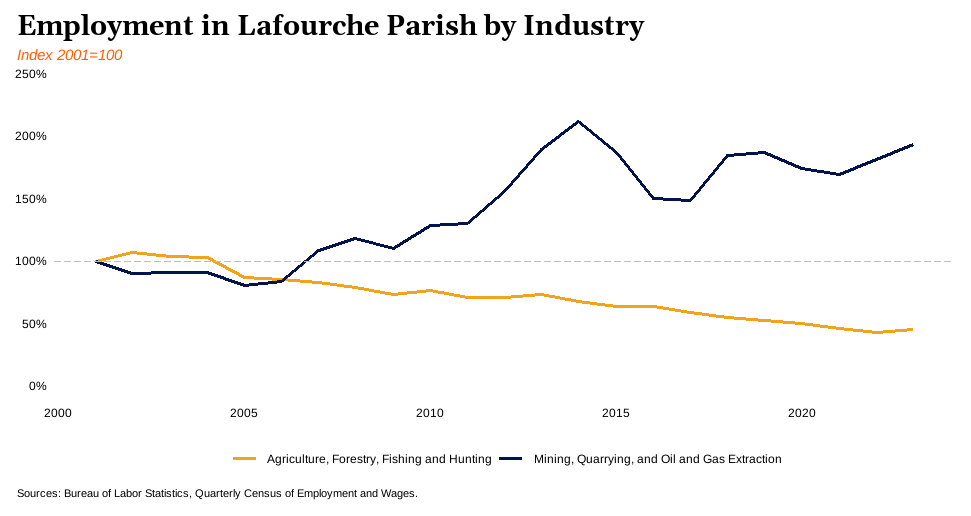
Marine construction and transportation also is a big industry in Lafourche Parish. In 2016, approximately 5,000 people in Lafourche and Terrebonne Parishes were employed by Edison Chouest Offshore, which specializes in designing, building, and operating vessels to supply offshore oil rigs (Boudreaux, 2017). The company is headquartered in Cut Off. Its subsidiary, C-Port, operates out of Golden Meadow and in 2016, employed approximately 1,500 people (Boudreaux, 2017). Edison Chouest also operates the North American Shipbuilding shipyard in Larose, and the Grand Isle Shipyard is headquartered in Galliano. Tracking these jobs with recent data can be difficult because positions can be classified under different industries such as construction, manufacturing, and transportation. According to 2023 American Community Survey (ACS) 5-year estimates, approximately 22 percent of all jobs in Lafourche Parish, equating to nearly 10,000 positions, are found within the combined industries (US Department of Commerce, 2023).
Other large industries in Lafourche Parish are education and health services and retail trade. Data from the 2023 ACS 5-year estimates found almost 25 percent of the workforce was employed in the “Educational services, and health care and social assistance” industry, which can include employers such as the Lafourche Parish schools system, Thibodaux Regional Medical Center, and Nicholls State University (Boudreaux, 2017; US Department of Commerce, 2023).
The retail trade industry — which encompasses store and non-store retailers that sell merchandise or provide services incidental to the sale of merchandise, such as repairs and installation (Bureau of Labor Statistics, 2025) — employed 11.8 percent of the workforce (US Department of Commerce, 2023). In 2017, the top retailer was Walmart, which had an estimated 900 part- and full-time workers in its Lafourche Parish locations (Boudreaux, 2017).
The final factor in understanding employment in Lafourche Parish is unemployment. According to the 2023 ACS data, Lafourche Parish had a 5.5 percent unemployment rate. However, the rate varies by location in South Lafourche. Data from the 2023 ACS 5-year estimates shows that Larose had the highest unemployment rate in the region at 9.6 percent, followed by Galliano with 5.7 percent, Golden Meadow with 2.8 percent, and Cut Off with 2.5 percent (US Department of Commerce, 2023). Per the CDC social vulnerability index data, the census tract containing Larose was in the 74th percentile in 2022 for percentage of civilians (age 16+) unemployed (Centers for Disease Control and Prevention/ Agency for Toxic Substances and Disease Registry/ Geospatial Research, Analysis, and Services Program, 2022).
The data in this section provide a picture of South Lafourche today, and the results are mixed. The Larose to Golden Meadow Hurricane Protection System has likely had a positive impact in reducing the number of flood insurance claims per hurricane event in Lafourche Parish. However, the complexities of social vulnerability, rising insurance costs, and varying unemployment rates across South Lafourche communities indicate that the system alone does not address all the challenges residents face. While the region benefits from its proximity to oil and natural gas operations and the headquarters of related industries such as marine construction, economic disparities and the high rate of uninsured homes highlight ongoing vulnerabilities.
The next section will discuss the findings and policy implications.
South Lafourche’s issues are ongoing. Research suggests that global warming will likely intensify hurricane-related extreme rainfall and accompanying flooding (Balaguru et al., 2023; Li et al., 2023). Combine Louisiana’s sinking land with natural erosion, which requires constant upkeep of levees, and the work on the Larose to Golden Meadow system is not done. Thankfully, there is a lot local, state, and federal governments can do to improve the situation. This section offers policy suggestions derived from the preceding analysis.
The most obvious solution is that the US Army Corps should conduct a study of the post-Katrina work that has been done to the Larose to Golden Meadow system and work with the South Lafourche Levee District on a re-certification plan that minimizes costs on the local side. If the levee system upgrades have protected communities despite the Army Corps’ warnings, perhaps there is a lesson there about levee standards and how a one-size-fits-all flood control solution does not work for different parts of the United States. If there are issues found with the upgrades, local, state, and federal stakeholders can work together to find the best solution. Likewise, FEMA should include existing flood control structures in its flood insurance rate maps and calculations, even if they are not certified. FEMA certainly has the ability to conduct a more thorough analysis than this paper on the changes to claims since controls have been built. And while decertified levees cannot guarantee a larger reduction in rates, they still change the risk profile of a community.
However, any suggestions around more involvement from the federal government have to take into account the current uncertainty around federal funding for disaster preparedness and recovery efforts as well as the future status of FEMA (Moreno, 2025; Painter, 2025). A significant finding from this analysis is that resilience and climate mitigation can be built and funded from the community up even in the riskiest locations. The story of the Larose to Golden Meadow Hurricane Protection system, particularly the actions taken after Hurricane Katrina, highlights the ability of communities to utilize local resources to protect their homes. That funding needs to be secured for future generations.
One problem is that most coastal restoration and protection work in Louisiana is funded by money paid out in a settlement after the Deepwater Horizon disaster in 2010. The funding could run out by 2031, depending on the amount of interest accrued on the unpaid balance (Sedlar, 2024). As mentioned previously, GOMESA funds have been used to support the Larose to Golden Meadow system. Congress has attempted to expand GOMESA revenue sharing and include revenue from offshore wind farms under the Reinvesting In Shoreline Economies and Ecosystems (RISEE) Act of 2023 (Sen. Whitehouse, 2024). Congress should support that expansion to help Gulf Coast states cover the costs of protecting communities and the environment from the extraction industries and their infrastructure, which were put in place before environmental impacts were researched.
Another potential source of funding comes from a recent development. In an April 2025 ruling, a jury ordered Texaco’s parent company Chevron to pay Plaquemines Parish $744 million for damages to wetlands caused by oil and gas infrastructure and extraction activities. The ruling paves the way for similar outcomes in multiple lawsuits filed by coastal parishes going back 12 years. In 2013, 42 lawsuits were filed by New Orleans and six of the 17 coastal zone parishes claiming oil and gas companies violated Louisiana’s State and Local Coastal Resources Management Act of 1978, and that coastal parishes are due compensation because of the fast deterioration of wetlands tied to the companies’ actions (Sedlar, 2025b). The success of Plaquemines’ case could mean more money for coastal restoration and protection work, and it may lead to similar outcomes for other parishes against Chevron and other oil and gas companies operating in the area.
However, this strategy is not ideal; litigation can take years, as the current ruling demonstrates. Also, it is worth noting Lafourche Parish has not joined other coastal parishes in filing suits against oil and gas companies. The close ties between Lafourche and the oil and gas industry, including the number of residents employed by it, suggest a reluctance to act against the parish’s major employers. Pursuing a case against oil and gas companies could be politically unpopular and risky, which limits Lafourche’s options to the previously mentioned funding sources.
Some critics may question why local, state, and federal governments should continue spending money securing communities in repeated risk areas. This paper highlights one argument for why managed retreat is not a solution for most communities in South Lafourche. The first is that the risk is not just to the communities but also to Port Fourchon and the associated transportation and oil and gas infrastructure.
Port Fourchon services around 95 percent of deepwater energy production in the Gulf of Mexico and supplies about 15 percent of the United States’ oil (Greater Lafourche Port Commission, 2017b). Damage to that infrastructure would create massive economic losses and environmental damage in the form of oil spills. No matter how people feel about oil and gas extraction, the infrastructure is there and vulnerable.
A second argument is that community relocation is a complicated process that is often fraught with controversy. Part of the issue is that there is currently no single source for funding or planning community relocation efforts. A variety of federal agencies have funded relocation efforts in the past, including but not limited to various FEMA programs and Department of Housing and Urban Development block grants. In 2024, a White House report (Community-Driven Relocation Subcommittee of the National Climate Task Force, 2024) was released detailing ways the federal government can support community-driven relocation efforts in areas that experience repeated climate-driven disasters. However, the report was removed by the Trump Administration in early 2025 (Sedlar, 2025a).
Without centralized support for a community-led effort to relocate housing, Louisiana could repeat past mistakes, specifically what occurred during the relocation of residents of Isle de Jean Charles. In 2016, Louisiana received $48.3 million from the US Department of Housing and Urban Development to aid residents of Isle de Jean Charles in a structured relocation. The funds, awarded through a Community Development Block Grant, were intended to facilitate the relocation process among residents, the parish, and other involved parties. The process also had the potential to “serve as a model for other states and communities facing similar challenges by establishing a proactive climate-based relocation framework to assist communities throughout the nation and across the globe facing similar types of issues including ongoing land loss and increasing flood risk” (Louisiana Office of Community Development, 2020, p. 6). Instead, the Isle de Jean Charles resettlement has only demonstrated the difficulties and complexities involved in relocating communities.
The island, which sits just west of South Lafourche, was home to the Jean Charles Choctaw Nation, comprising 775 members of Biloxi, Chitimacha, and Choctaw ancestry, and members of the United Houma Nation. Most of Isle de Jean Charles is below sea level and facing severe land loss due to subsidence and sea-level rise. The resettlement program aimed to support residents by relocating them to safer housing and working together to design a new community, called New Isle, 40 miles inland. However, in a civil complaint filed under Title VI of the Civil Rights Act, the Jean Charles Choctaw Nation alleged Louisiana’s Office of Community Development (OCD) discriminated against tribal members during the process. The complaint states OCD made unilateral changes to a resettlement program the tribe developed, changed the tribe’s status from grant beneficiary to stakeholder, and removed or minimized cultural elements and components that considered flood and disaster resilience in the new location (Chief Deme Warrior Buffalo Naquin Jr., 2023). Since August 2022, 34 of the 41 families who showed interest in relocating have moved to the New Isle. Three families decided not to move, and the remaining families relocated elsewhere within the state (Sherriff, 2024).
Even before South Lafourche communities can discuss relocation, they need to know there is a system and funding in place to facilitate it — and right now, there is not. The federal government should revive the 2024 interagency report on community-driven relocation and consider its recommendations, especially the idea of establishing a single entry point for communities to access federal funding and technical assistance for relocation. Without a streamlined and community-driven process, communities only face confusion when dealing with an overwhelming and emotionally charged decision.
Finally, while this paper does not examine the damage to South Lafourche’s wetlands since the Larose to Golden Meadow system was built, the present condition of the wetlands (as shown in Figure 1) offers a glimpse of what happens when wetlands are caught between Gulf waters and levees — known as “shoreline squeeze.” Projects like building more gradual slopes on the seaward side of a levee or restoring native plants in wetlands can save critical habitats and create more jobs. And in many parts of coastal Louisiana, that work is already happening. Currently, the state and federal government are spending over $1 billion on coastal protection and restoration work along the Louisiana coast. However, according to the majority of employers who responded to the 2024 Gulf Coast Coastal Work Industry Insights Survey (Sedlar, 2024), the biggest challenge facing most companies is attracting and retaining workers. Louisiana needs to invest more in a formal workforce intermediary program that connects individuals to employers and accredited training programs. Subsequently, a formal workforce intermediary could advocate for high-quality jobs within the industry and facilitate the development of a hybrid training program that blends certification programs with practical experience through on-the-job training.
South Lafourche’s challenges are not going away. The situation will need to be constantly reanalyzed because of the complexities of water ecology in relation to land subsidence and sea-level rise. On top of those challenges, there is uncertainty around funding solutions. Federal funding is decreasing under the Trump Administration, and Deepwater Horizon settlement money may run out by 2031. There are opportunities for Louisiana, Congress, and the White House to make a big impact in this area. Expanding GOMESA revenue through the RISEE Act is a good first step in creating a larger, steadier stream of funding for coastal protection and restoration work. To make disaster mitigation and housing relocation more efficient, the White House should consolidate funding and assistance by reviving the previous administration’s community-driven relocation initiatives. This would simplify the current complex involvement of multiple agencies and offices.
The story of South Lafourche is the story of the constant struggle between human settlement and the dynamic forces of nature. The region’s geography, dominated by the Mississippi River delta and the waters of the Gulf of Mexico, has helped shape its culture, economy, and ultimately its vulnerability. The construction of the Larose to Golden Meadow Hurricane Protection System marked a step in the direction of mitigating those vulnerabilities, but it is not a cure-all. As this paper has shown, complex issues such as social vulnerability, rising insurance costs, and economic disparities also play a role in the region’s adaptations to climate-related challenges.
While it is likely the Larose to Golden Meadow system has reduced flood insurance claims, it has not eliminated all of the region’s challenges. Land subsidence, sea-level rise, and ever-increasing storms are all the product of a changing climate. The dependence on oil and gas also poses risks for both the region and the nation. While the industry provides employment, the infrastructure that snakes through South Lafourche’s wetlands has caused environmental damage that exacerbates the impact of climate-related disasters.
Ultimately, the future of South Lafourche depends on solutions that combine infrastructure with community-driven resilience strategies. This includes addressing social vulnerabilities, bringing down the cost of flood insurance, diversifying the region’s economy, and investing in workforce development for a growing coastal protection and restoration industry. Part of this effort relies on consistent and streamlined federal funding for disaster preparedness, recovery, and — in worst case scenarios — community-driven relocation. But this funding must acknowledge and incorporate local expertise and needs. South Lafourche’s ongoing challenges underscore the need for adaptive and flexible policies that can respond to the ever-changing relationship between the region’s communities and its environment. Otherwise, the unique history of the region and its people will be lost to Gulf waters.
Allain-Lebreton Co. v. Department of Army, New Orleans Dist., Corps of Engineers (March 11, 1982). https://heinonline.org/HOL/CaseLaw?1=1&native_id=574578&collection=fastcasefull
Alperin, L. M. (1983). History of the Gulf Intracoastal Waterway. University of Michigan Library.
Atchafalaya National Heritage Area. (2017, October 29). Bayou Teche at Sovereign Nation of the Chitimacha. Atchafalaya Water Heritage Trail. http://waterheritage.atchafalaya.org/trail-sites.php?trail=Chitimacha-Indian-Reservation
Bahr, E. (2006, October 20). South Lafourche voters to consider sales-tax increase. The Daily Comet. https://www.houmatoday.com/story/news/2006/10/21/south-lafourche-voters-to-consider-sales-tax-increase/26714917007/
Balaguru, K., Xu, W., Chang, C.-C., Leung, L. R., Judi, D. R., Hagos, S. M., Wehner, M. F., Kossin, J. P., & Ting, M. (2023). Increased U.S. coastal hurricane risk under climate change. Science Advances, 9(14), eadf0259. https://doi.org/10.1126/sciadv.adf0259
Ballard, M. (2024, November 30). Many in Louisiana think flood insurance is broken. But what can be done about it? NOLA.Com. https://www.nola.com/news/politics/congress-mulls-different-ideas-for-fixing-flood-insurance/article_a3e2d662-ae91-11ef-a036-cbc903e18ef2.html
Banta, B. (1981). The Regulation and Conservation of Petroleum Resources in Louisiana, 1901-1940. (Volumes I and II). [Doctor of Philosophy, Louisiana State University and Agricultural & Mechanical College]. https://doi.org/10.31390/gradschool_disstheses.3669
Becnel, T. A. (1962). A History of the Louisiana Shrimp Industry, 1867-1961 [M.A., Louisiana State University and Agricultural & Mechanical College]. https://www.proquest.com/docview/2640411885/abstract/E04C0E2882A44F58PQ/1
Bernard, S. K. (2003). The Cajuns: Americanization of a people (1st ed.). University Press of Mississippi.
Boudreaux, D. (2017, September 28). Edison Chouest is Lafourche’s top employer. The Courier. https://www.houmatoday.com/story/business/2017/09/28/making-list-lafourches-10-largest-employers/18710208007/
Bush, G. W. (2005, December 30). President’s Statement on Signing of H.R. 2863, the “Department of Defense, Emergency Supplemental Appropriations to Address Hurricanes in the Gulf of Mexico, and Pandemic Influenza Act, 2006” [Government]. The White House. https://georgewbush-whitehouse.archives.gov/news/releases/2005/12/20051230-8.html
Campo, C. (2023, March 22). Thousands may be forced to buy flood insurance as FEMA flood maps are made official in Terrebonne. Houma Courier.
Carter, N., & Normand, A. (2024). Process for U.S. Army Corps of Engineers (USACE) Projects (R47946). https://crsreports.congress.gov/product/pdf/R/R47946
Carter, N. T., Hughes, H. S., Sheikh, P. A., & Zinn, J. A. (2007). Water Resources Development Act (WRDA) of 2007: Corps of Engineers Project Authorization Issues. https://crsreports.congress.gov/product/pdf/RL/RL33504/29
Centers for Disease Control and Prevention/ Agency for Toxic Substances and Disease Registry/ Geospatial Research, Analysis, and Services Program. (2022). CDC/ATSDR Social Vulnerability Index 2022 Database Louisiana [Dataset]. https://www.atsdr.cdc.gov/place-health/php/svi/svi-data-documentation-download.html#cdc_generic_section_2-data-changes-over-time
Chief Deme Warrior Buffalo Naquin Jr. (2023, December 21). Complaint Under Title VI of the Civil Rights Act of 1964, 42 U.S.C. § 2000d, and 40 C.F.R. Part 7 against the Louisiana Division of Administration, Office of Community Development for Discriminatory Implementation of the Federally Funded Isle de Jean Charles Resettlement Program. Jean Charles Choctaw Nation. https://earthrights.org/wp-content/uploads/2023/12/IDJC-Resettlement-Title-VI-Complaint-for-website.pdf
Chitimacha Tribe of Louisiana. (2013, May 17). Tribal History [Text]. Chitimacha Tribe of Louisiana. http://www.chitimacha.gov/history-culture/tribal-history
Cline, I. M. (1909). DISTRICT No. 7, LOWER MISSISSIPPI VALLEY. Monthly Weather Review, 37(9), 622–637. https://doi.org/10.1175/1520-0493(1909)37[622:DNLMV]2.0.CO;2
Cline, I. M. (1915). The Tropical Hurricane of September 29, 1915 in Louisiana. Monthly Weather Review, 43(9).
Community-Driven Relocation Subcommittee of the National Climate Task Force. (2024). Opportunities for Federal Support of Community-Driven Relocation. The White House. https://cepr.net/wp-content/uploads/2025/01/Opportunities-for-Federal-Support-of-Community-Driven-Relocation-vF-1.pdf
Cowdrey, A. E. (1977). Land’s end: A history of the New Orleans District, U.S. Army Corps of Engineers, and its lifelong battle with the lower Mississippi and other rivers wending their way to the sea. U.S. Army Corps of Engineers, New Orleans District. https://usace.contentdm.oclc.org/digital/collection/p16021coll4/id/107/rec/1
d’Oney, J. D. (2020). A Kingdom of Water: Adaptation and Survival in the Houma Nation. UNP – Nebraska. https://doi.org/10.2307/j.ctvwh8f3g
Darcy, J.-E. (2009, August 28). Report of the Secretary of the Army on Civil Works Activities for FY 2008. US Army Corps of Engineers. https://usace.contentdm.oclc.org/utils/getfile/collection/p16021coll6/id/376
Darcy, J.-E. (2012, October 1). Report of the Secretary of the Army on Civil Works Activities for FY 2011. US Army Corps of Engineers. https://usace.contentdm.oclc.org/utils/getfile/collection/p16021coll6/id/1539
Din, G. C. (Ed.). (1996). The Spanish presence in Louisiana, 1763-1803. Center for Louisiana Studies, University of Southwestern Louisiana.
Ditto, T. B. (1980). The Longest Street. Moran Publishing Corporation.
Doucet, J. P. (2019). A River Ran Through It: Historical Golden Meadow as Gateway to the Gulf. Folklife in Louisiana. https://www.louisianafolklife.org/lt/articles_essays/lfmriverran.html
Environmental Protection Agency. (2013, July 31). What is the National Environmental Policy Act? [Overviews and Factsheets]. https://www.epa.gov/nepa/what-national-environmental-policy-act
Environmental Protection Agency. (2016, October 4). EPA History: Water – The Challenge of the Environment: A Primer on EPA’s Statutory Authority [Policies and Guidance]. https://www.epa.gov/archive/epa/aboutepa/epa-history-water-challenge-environment-primer-epas-statutory-authority.html
Federal Emergency Management Agency. (2020, August). History of Levees. https://www.fema.gov/sites/default/files/2020-08/fema_history-of-levees_fact-sheet_0512.pdf
Federal Emergency Management Agency. (2021, May). Meeting the Criteria for Accrediting Levee Systems on Flood Insurance Rate Maps. Federal Emergency Management Agency. https://www.fema.gov/sites/default/files/documents/fema_meeting-criteria-accrediting.pdf
Federal Emergency Management Agency. (2025). NFIP Residential Penetration Rates—V1 (Version 1) [CSV]. https://www.fema.gov/openfema-data-page/nfip-residential-penetration-rates-v1
Gaudet, K. A. (2006, May 9). Levee district wins approval to sell bonds. NYT Regional Newspapers. https://www.houmatoday.com/story/news/2006/05/09/levee-district-wins-approval-to-sell-bonds/26700240007/
Greater Lafourche Port Commission. (2017a, February 2). GLPC History. Greater Lafourche Port Commission. https://portfourchon.com/about-glpc/glpc-history/
Greater Lafourche Port Commission. (2017b, February 2). Port Facts. https://portfourchon.com/seaport/port-facts/
Hearings Before The Special Subcommittee to Investigate Areas of Destruction of Hurricane Betsy: Hearing before the Committee of Public Works, House of Representatives (1965). https://li.proquest.com/elhpdf/histcontext/HRG-1965-PWH-0010.pdf#:~:text=Lafourche%20in%20Lafourche%20Parish%2C%20Congressman%20Wilfis%27%20district%2C,are%20up%20on%20top%20of%20the%20roofs
Horowitz, A. (2020). Katrina: A history, 1915-2015. Harvard University Press.
Interagency Performance Evaluation Task Force. (2009, June). Performance Evaluation of the New Orleans and Southeast Louisiana Hurricane Protection System. US Army Corps of Engineers. https://biotech.law.lsu.edu/katrina/ipet/Volume%20I%20FINAL%2023Jun09%20mh.pdf
Kane, H. T. (1943). The Bayous of Louisiana. Bonanza Books.
Kennedy, C. (2013, May 20). Thriving on a Sinking Landscape. Climate.Gov. http://origin-east-01-drupal-climate.woc.noaa.gov/news-features/features/thriving-sinking-landscape
Leatherwood, A. (1976). Gulf Intracoastal Waterway. Texas State Historical Association. https://www.tshaonline.org/handbook/entries/gulf-intracoastal-waterway
Li, X., Fu, D., Nielsen-Gammon, J., Gangrade, S., Kao, S.-C., Chang, P., Morales Hernández, M., Voisin, N., Zhang, Z., & Gao, H. (2023). Impacts of climate change on future hurricane induced rainfall and flooding in a coastal watershed: A case study on Hurricane Harvey. Journal of Hydrology, 616, 128774. https://doi.org/10.1016/j.jhydrol.2022.128774
Louisiana Coastal Protection and Restoration Authority. (2007, April 30). Integrated Ecosystem Restoration and Hurricane Protection: Louisiana’s Comprehensive Master Plan for a Sustainable Coast. Louisiana Coastal Protection and Restoration Authority. https://cims.coastal.louisiana.gov/RecordDetail.aspx?Root=0&sid=670#
Louisiana Coastal Protection and Restoration Authority. (2010, April). Fiscal Year 2011 Annual Plan: Integrated Ecosystem Repair and Hurricane Protection in Coastal Louisiana. Louisiana Coastal Protection and Restoration Authority. https://gestaltgraphics.com/wp-content/uploads/2023/01/CPRA-FY2011.pdf
Louisiana Coastal Protection and Restoration Authority. (2013, November 19). Larose to Golden Meadow—Flood Protection. Coastal Protection And Restoration Authority. https://coastal.la.gov/project/larose-to-golden-meadow-levee-system/
Louisiana Office of Community Development. (2020, November 10). Isle de Jean Charles Resettlement Homebuyer Assitance Program Policies. Louisiana Division of Administration. https://isledejeancharles.la.gov/sites/default/files/public/IDJC%20Policies_For%20Publishing_20201110v2.pdf
Louisiana State Legislature. (n.d.). Louisiana Civil Code Article 665 [Government]. Retrieved February 6, 2025, from https://legis.la.gov/legis/Law.aspx?d=110859
McNamara, P. (1965, October 20). Southeast hurricane disaster relief act of 1965. Congressional Report. U.S. Congress. Senate Committee on Public Works.
Mehta, J. M., & Rodning, C. B. (2022). Environment, Climate, and Mississippian Origins in the Lower Mississippi Valley and the Mississippi River Delta. In Following the Mississippian Spread (pp. 357–376). Springer International Publishing. https://doi.org/10.1007/978-3-030-89082-7_12
Melendez, S. (2024, May 7). Windell Curole—ANTIGRAVITY Magazine. https://antigravitymagazine.com/feature/windell-curole/
Moreno, I. (2025, February 24). Trump’s Cuts to FEMA Leave Us Unprepared for Disasters. Natural Resources Defense Council. https://www.nrdc.org/media/trumps-cuts-fema-leave-us-unprepared-disasters
Mumphrey, A. J., & Wagner, F. W. (1976). The impacts of outer continental shelf development on Lafourche Parish. https://repository.library.noaa.gov/view/noaa/16873
Nierlich, S. E. (1963). Linear structural patterns of settlement. Massachusetts Institute of Technology.
Painter, W. L. (2025). Disaster Relief Fund State of Play: In Brief [Legislation]. Congressional Research Service. https://www.congress.gov/crs-product/R47676
Parrish, S. S. (2018). The flood year 1927: A cultural history. Princeton University Press.
Police Jury Association of Louisiana. (2018, May 5). Parish Government Structure—The Forms of Parish Government. https://www.lpgov.org/page/ParishGovStructure
Rep. Oberstar, J. L. [D-M.-8. (2007, November 9). Text – H.R.1495 – 110th Congress (2007-2008): Water Resources Development Act of 2007 (2007-03-13) [Legislation]. https://www.congress.gov/bill/110th-congress/house-bill/1495/text
Roth, D. (2010, April 8). Louisiana Hurricane History. National Weather Service. https://www.wpc.ncep.noaa.gov/research/lahur.pdf
Rowan, P. J. (n.d.). Leon Theriot Evaluation Report. US Army Corps of Engineers, New Orleans District. Retrieved November 26, 2024, from https://www.mvn.usace.army.mil/Portals/56/docs/Projects/EIS%20Larose%20to%20Golden%20Meadow.pdf?ver=2018-02-16-104555-757
Rumbach, A., Sullivan, E., & Makarewicz, C. (2020). Mobile Home Parks and Disasters: Understanding Risk to the Third Housing Type in the United States. Natural Hazards Review, 21(2), 05020001. https://doi.org/10.1061/(ASCE)NH.1527-6996.0000357
Sedlar, M. (2023). Climate Change and the Future of Catastrophe Insurance Programs. https://cepr.net/publications/climate-change-and-the-future-of-catastrophe-insurance-programs/
Sedlar, M. (2024). Who is Saving Coastal Louisiana? The Workforce and Industry Behind Coastal Protection and Restoration. Center for Economic and Policy Research. https://cepr.net/publications/who-is-saving-coastal-louisiana-the-workforce-and-industry-behind-coastal-protection-and-restoration/
Sedlar, M. (2025a, January 16). Federal Support for Community-Driven Relocation: Progress and Possibilities. Center for Economic and Policy Research. https://cepr.net/publications/federal-support-for-community-driven-relocation/
Sedlar, M. (2025b, April 14). Louisiana Wetlands Win: Plaquemines Ruling Sets Precedent. CEPR. https://cepr.net/publications/louisiana-wetlands-win/
Sen. Whitehouse, S. [D-R. (2024, November 21). S.373 – 118th Congress (2023-2024): RISEE Act of 2023 (2023-02-09) [Legislation]. https://www.congress.gov/bill/118th-congress/senate-bill/373
Sherriff, L. (2024, January 30). This Louisiana town moved to escape climate-linked disaster. BBC News. https://www.bbc.com/future/article/20240130-this-louisiana-town-moved-to-escape-climate-disaster
South Lafourche Levee District. (2024, May 7). History. SLLD. https://www.slld.org/history
Sprehe, B. (2004, February). Louisiana Energy Topic. Louisiana Department of Natural Resources. https://www.dnr.louisiana.gov/assets/docs/energy/newsletters/2001_2005/2004-02_topic.pdf
Staff Writer. (1909, September 22). Definite Reports from Gulf Storm. Lewiston Evening Journal. https://news.google.com/newspapers?id=fnggAAAAIBAJ&sjid=fWcFAAAAIBAJ&dq=louisiana%20hurricane&pg=2677%2C1135520
Staff Writer. (2018, July 11). Lafourche Ring Levee. The Times of Houma/Thibodaux. https://houmatimes.com/hurricane-guide/lafourche-ring-levee/
State of Louisiana, et al. v Department of Homeland Security et Al., 2:23-cv-01839-DJP-EJD (United States District Court, Eastern District of Louisiana March 28, 2024). https://climatecasechart.com/wp-content/uploads/case-documents/2024/20240328_docket-223-cv-01839_order.pdf
Storey, W. K. (2005). Two Rivers Unleashed. Part 1, “The 1927 Mississippi River Flood.” Part 2, “The 1979 Pearl River Flood.” The Public Historian, 27(1), 90–93. https://doi.org/10.1525/tph.2005.27.1.90
Tate, E., Rahman, M. A., Emrich, C. T., & Sampson, C. C. (2021). Flood exposure and social vulnerability in the United States. Natural Hazards, 106(1), 435–457. https://doi.org/10.1007/s11069-020-04470-2
Terrebonne v. South Louisiana Tidal Water Control Levee Dist. (April 13, 1982). https://heinonline.org/HOL/CaseLaw?1=1&native_id=2010550&collection=fastcasefull
The Historical Marker Database. (2023, September 1). Larose Historical Marker. https://www.hmdb.org/m.asp?m=85767
The State of Louisiana et al. v Alejandro Mayorkas, the Department of Homeland Security, Deanne Criswell, the Federal Emergency Management Agency, and the Federal Insurance and Mitigation Administration, 2:23-cv-01839-JCZ-JVM (United States District Court, Eastern District of Louisiana June 1, 2023). https://climatecasechart.com/wp-content/uploads/case-documents/2023/20230601_docket-223-cv-01839_complaint-1.pdf
Theriot, J. P. (2014). American energy, imperiled coast: Oil and gas development in Louisiana’s wetlands. Louisiana State University Press.
Thibodaux Chamber of Commerce. (2001, January 31). Thibodaux & Parish History. http://www.thibodauxchamber.com/thibodaux-parish-history
Thornton, K., & Juarez, T. (2024, August 28). This man saved his town from deadly floodwaters. So why did the US government try to stop him? The Guardian. https://www.theguardian.com/environment/article/2024/aug/28/louisiana-bayou-levee-gulf
US Army Corps of Engineers. (1967). Annual report of the Chief of Engineers, U.S. Army on Civil Works activities, 1967. U.S. Government Printing Office. https://usace.contentdm.oclc.org/digital/collection/p16021coll6/id/1404/rec/17
US Army Corps of Engineers, New Orleans District. (1984, November). Final Supplemental Environmental Impact Statement, Larose to Golden Meadow Louisiana Hurricane Protection Project. https://apps.dtic.mil/sti/tr/pdf/ADA143734.pdf
US Army Corps of Engineers, New Orleans District. (1987a). Final Mitigation Report for the Larose to Golden Meadow, Louisiana, Hurricane Protection Project. https://www.mvn.usace.army.mil/Portals/56/docs/Projects/Larose%20to%20Golden%20Meadow%20Mitigation.pdf?ver=2018-02-16-105049-413
US Army Corps of Engineers, New Orleans District. (1987b, May). 1985 Hurricanes, Juan, Danny, Elena; Nineteen eighty five hurricanes. US Army Corps of Engineers, New Orleans District. https://usace.contentdm.oclc.org/digital/collection/p266001coll1/id/2414/rec/1
US Army Corps of Engineers, New Orleans District. (2007, February 23). Army Corps of Engineers Council on Environmental Quality Emergency Alternative Arrangements. US Army Corps of Engineers. https://biotech.law.lsu.edu/blog/USACE_alternative_arrangements_NEPA_process.pdf
US Army Corps of Engineers, New Orleans District. (2011, April 5). Grand Isle, Louisiana and Vicinity (Larose to Vicinity of Golden Meadow) Hurricane Protection Project Review Plan. US Army Corps of Engineers. https://www.mvn.usace.army.mil/Portals/56/docs/PD/PeerReview/Larose-GoldenMeadowRP-Construction.pdf
US Army Corps of Engineers, New Orleans District. (2014, March 14). Larose to Golden Meadow Hurricane Protection [Government]. US Army Corps of Enginers. https://www.mvn.usace.army.mil/About/Projects/Larose-to-Golden-Meadow/
US Army Engineer District, New Orleans. (1973, November). Final environmental statement: Larose to Golden Meadow, Louisiana, hurricane protection (formerly Grand Isle, Louisiana, and vicinity hurricane protection. US Army Engineer District, New Orleans, New Orleans, Louisiana. https://usace.contentdm.oclc.org/digital/collection/p16021coll7/id/15908/
US Department of Commerce, U. C. (2023). Selected Economic Characteristics [Dataset]. American Community Survey, ACS 5-Year Estimates. https://data.census.gov/table/ACSDP5Y2023.DP03?q=unemployment&g=1400000US22057021200,22057021300,22057021400,22057021500
US Government Accountability Office. (2024, July 17). Army Corps of Engineers: Additional Steps Needed to Implement Acceleration Reforms. https://www.gao.gov/products/gao-24-107072
US Office of Emergency Planning. (1966). Hurricane Betsy: Federal Action in Disaster.
Woodley Jr., J. P. (2006, August 26). Report of the Secretary of the Army on Civil Works Activities for FY 2005. Department of the Army. https://usace.contentdm.oclc.org/utils/getfile/collection/p16021coll6/id/334
Woodley Jr., J. P. (2008, August 22). Report of the Secretary of the Army on Civil Works Activities for FY 2007. Department of the Army. https://usace.contentdm.oclc.org/utils/getfile/collection/p16021coll6/id/362
Article
Article
Article
Article