Article
Disasters and Vanishing Land Are Leaving the Most Vulnerable Behind in Southeastern Louisiana
Article
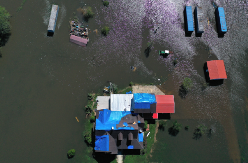
If the name Port Sulphur evokes images of fire and brimstone, that’s not entirely off base. Originally established as a company town by the Freeport Sulphur Company, it once was the largest city in Plaquemines Parish, Louisiana. Its rise to prominence was directly tied to the rich sulfur deposits that formed over millions of years due to the unique geological processes in the area. In the 1940s and 50s, the region experienced a boom as demand for sulfur grew during the war effort. But in 1978, mining ceased as resources were depleted, and the Freeport Sulphur Company moved on. The economy collapsed. Then, in 2005, Hurricane Katrina swept through — destroying the towns of Port Sulphur, Pointe à la Hache, Buras, Boothville, and Venice in lower Plaquemines. Then, on April 20, 2010, an explosion on the Deepwater Horizon rig off the southeastern coast released 134 million gallons of oil into the Gulf. Between the 2000 and 2020 censuses, the population of Port Sulphur dropped from 3,264 to 1,677 residents, or 48 percent. This decline was before Hurricane Ida struck in 2021.
These days, hurricanes aren’t the only major threat to Plaquemines Parish. Through the combination of subsidence — land literally sinking from the previously noted resource extraction — and rising sea waters, the Gulf of Mexico is slowly swallowing lower Plaquemines. Every 100 minutes, the Louisiana coast loses a football field-sized parcel of land to the Gulf, and the effect is becoming increasingly visible. In October 2011, cartographers with the National Oceanic and Atmospheric Administration (NOAA) conducted a shoreline survey of coastal Louisiana. They discovered that 31 named bodies of water—bays, bayous, and canals—had vanished, with the majority of these located in Plaquemines (Figure 1). The open water of the Gulf has swallowed these once-distinct waterways; the land that gave them definition is now gone.
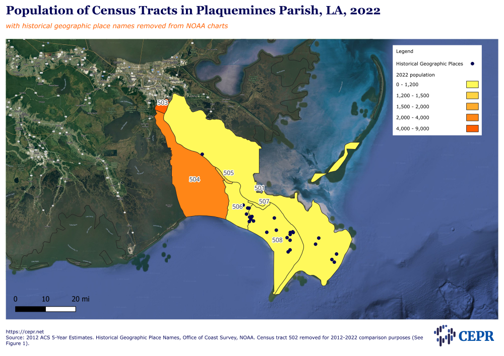
Figure 1
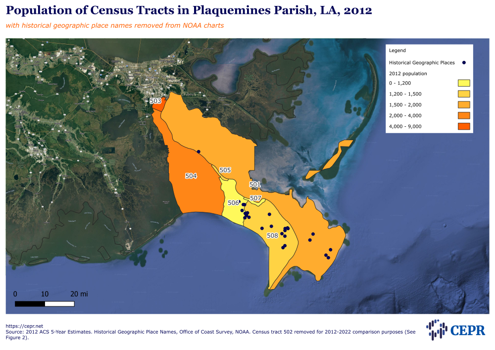
And as the sea waters rise, the population is shifting to more inland areas of Plaquemines (Figure 2).
Figure 2
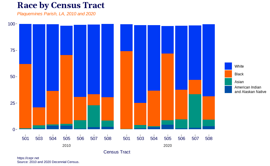
As populations have shifted, so have demographics (Figure 3). In Point Sulphur, the share of the Black population grew from a plurality of 49 percent during the 2000 Census to a majority of 63 percent in 2020.
In Buras, Louisiana, more and more Southeast Asian immigrants from Vietnam and Cambodia have migrated to the region to work in the fishing industry as other populations have declined. Between 2010 and 2020, the Asian population in Buras increased from 22 percent to 31 percent.
In the historic Black community of Pointe à la Hache, though the population is declining, the share of Black population in the surrounding census tract grew from 61 percent in 2010 to 74 percent in 2020. The region was known for its small group of Black oystermen working in the waters off Plaquemines, but the 2010 Deepwater Horizon spill destroyed the industry. In 2013, the Department of Justice approved a $4 billion criminal settlement outlining BP’s involvement in the spill, with $1.2 billion of the funds directed to the National Fish and Wildlife Foundation for coastal restoration projects in Louisiana. But that money won’t last forever.
Figure 3
Another demographic shift has been an increase in those living below the poverty level (Table 1). Those who remain despite declining economies, hurricanes, oil spills, and sea-level rise are, unsurprisingly, the poorest Louisianans. Based on 2022 ACS 5-year estimates, the median household income in Port Sulphur was $31,325 compared with the statewide median income of $55,416. In Buras, the median household income was $34,518, and in Pointe à la Hache, the median income was $11,781. The 2022 ACS 5-year estimates for unemployment rates in Port Sulphur, Buras, and Pointe à la Hache are 54.1 percent, 53.6 percent, and 30.2 percent, respectively.
| Census Tract | 2012 | 2022 | Percentage Difference |
|---|---|---|---|
| 501 | 14.5 | 39.6 | +173.1 |
| 503 | 7.5 | 14.9 | +98.7 |
| 504 | 8.3 | 14.5 | +74.7 |
| 505 | 23.2 | 19.4 | -16.4 |
| 506 | 9.2 | 49.6 | +439.1 |
| 507 | 15.6 | 34.3 | +119.9 |
| 508 | 35.1 | 33.7 | -4.0 |
Source: 2012 and 2022 ACS 5-Year Estimates.
The situation in Plaquemines Parish is merely a microcosm of the sea-level rise in the US. But the data available presents a stark reality. In a future in which sea-level rise will continue to claim land in coastal cities such as New Orleans, Norfolk, and Miami — among others — those individuals and communities that are already the most disenfranchised and vulnerable will bear the brunt of the consequences.
Current mitigation and adaptation work must emphasize vulnerable populations’ needs and concerns, ensuring active participation and inclusion in decision-making processes. Furthermore, policies and initiatives should strengthen these communities’ resilience by providing them with the resources and support systems they need to deal with the effects of increasing sea levels. When all else fails, an equitable managed retreat strategy should be considered.